At Drone Works Consultancy (DWC), we offer UAV surveying and mapping services that enable efficient, contact-free, and highly precise 3D surveys of large and hard-to-access areas. Using photogrammetry and laser scanning technologies, we generate a 3D point cloud from the data captured during UAV flights. This data is processed to produce accurate, georeferenced orthomosaic photos, digital terrain models (DTMs), and other vital mapping results.
1. 3D UAV Point Clouds: Detailed 3D documentation created from UAV surveys, capturing precise surface structures.
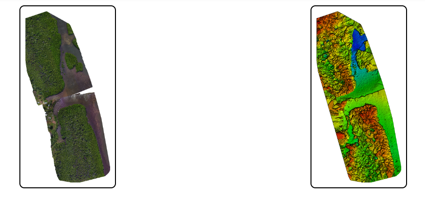
2. Orthomosaic Photos: High-resolution, georeferenced orthomosaic photos for the accurate depiction of the earth’s surface, façades, towers, or bridges
3. Digital Terrain Models (DTM/DSM): Accurate models of terrain elevation for use in GIS, CAD, or BIM software.
4. 2D Drawings and 3D Models: Essential for topographic maps, as-built plans, and other construction documentation.
5. Volume and Quantity Calculations: Exact measurements for landfills, quarries, and stockpiles, allowing for accurate tracking of volume changes over time.
6. Monitoring and Documentation: Slope movement: Exact measurements for landfills, quarries, and stockpiles, allowing for accurate tracking of volume changes over time.
7. Target/Actual Comparisons: Ensuring accurate tracking of volume changes and development conditions over time.
8. Georeferenced Orthomosaic Photos : Accurate spatial data for use in surveying, cartography, GIS applications, and urban planning.
9. Ground Sampling Distance (GSD) : High-resolution aerial imagery to meet specific project requirements.